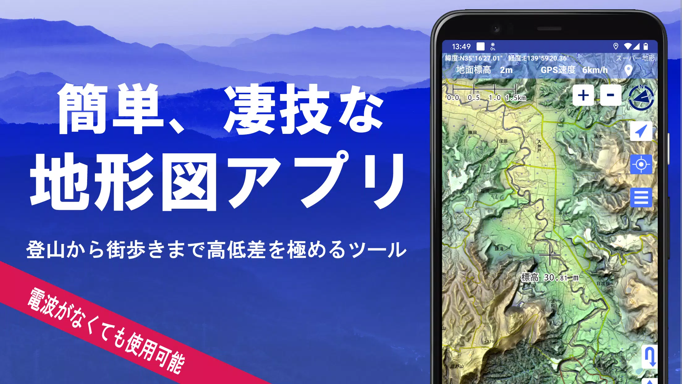
Explore over 100 diverse map types, including the renowned Geographical Survey Institute map, to enhance your experience from mountain climbing to leisurely strolls around town. With our app, you can leverage the height differences across various terrains to your advantage.
Our application was honored with the 2018 Japan Cartographic Society Award for Best Work, recognizing its excellence and utility in cartography.
- Utilize "super terrain data" to enhance your understanding of the terrain with our unique technology.
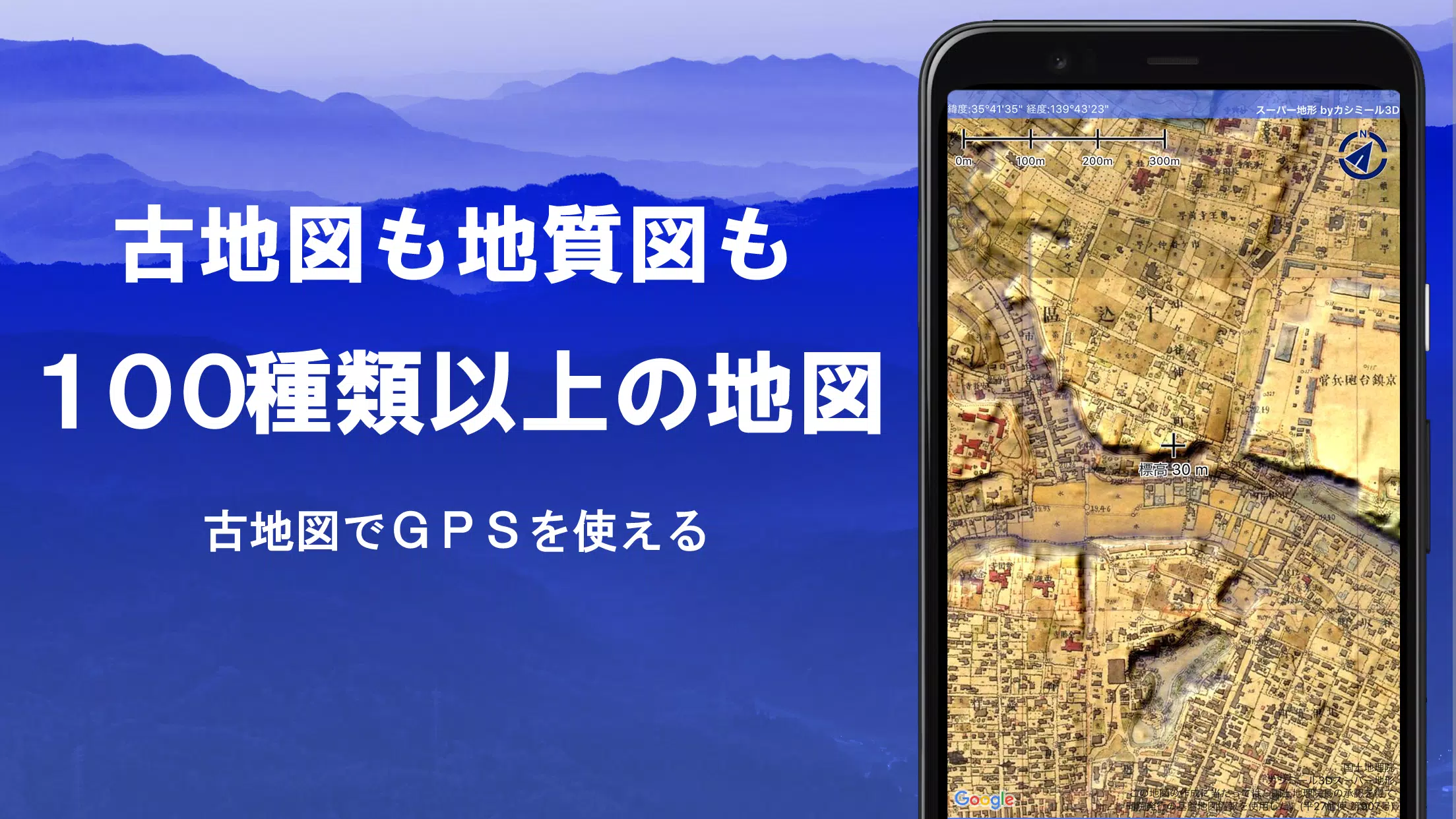
- Access an extensive range of maps from the Geospatial Information Authority of Japan, including topographic, geological, historical, and prewar Ordnance Survey Department maps.
- Record your journeys with the GPS function, which also supports GPX log input/output and editing.
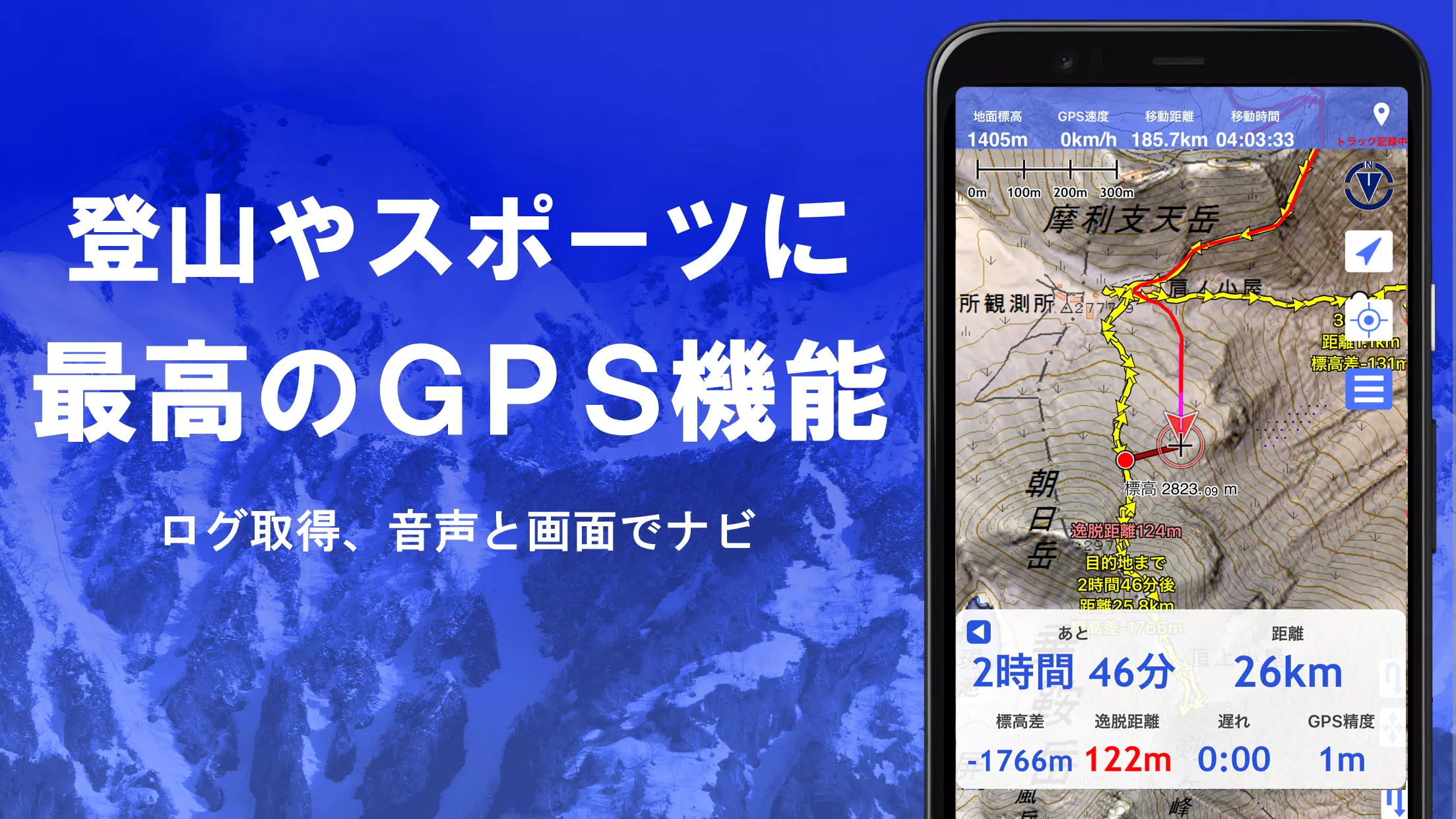
- Benefit from features tailored for urban exploration, mountain climbing, and other outdoor activities, such as GPS navigation with audio cues and data recording/editing capabilities.
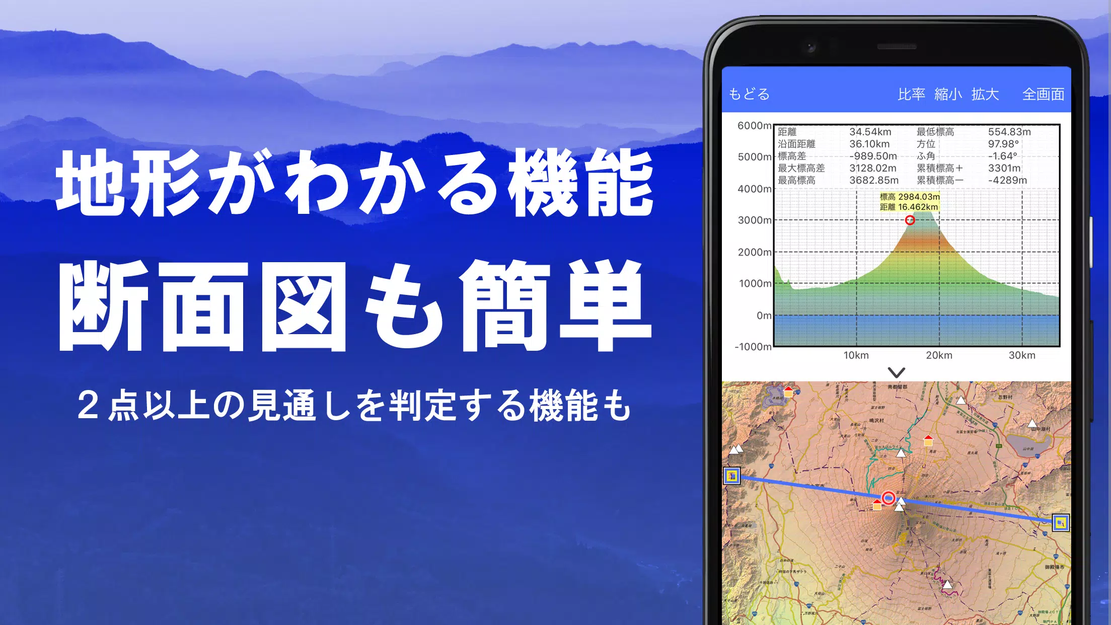
- Use the visibility determination function for creating cross-sectional diagrams and assessing observation and radio conditions; this feature also allows for building visualization.
- Enjoy a 360° panoramic view function, which includes mountain identification and displays of the sun, moon, and GPS points.
- Experience seamless offline use with GPS functionality, bulk map downloads, and a map cache feature, ideal for areas with no radio signal.
- Associate photos with specific points on your map.
- Visualize contour lines generated from elevation data.
- Display the MGRS grid (UTM grid) for precise location mapping.
- Read, display, and edit GIS data from GeoJSON files.
- Draw custom shapes directly on the map.
- Utilize the app overseas for global navigation.
- Print maps or export them as PDFs for easy sharing.
- Enhance your viewing experience with a dark theme option.
A Wealth of Maps at Your Fingertips
Our app boasts over 100 map types, including our own super topographic data and maps from the Geospatial Information Authority of Japan, along with hazard maps. Please note that availability of aerial photographs may vary by age group, with the most comprehensive coverage for "latest" and "around 1974" periods. Enjoy a 5-day free trial of maps using super terrain data upon installing the app.
Creating Cross Sections and Outlooks
Effortlessly draw cross sections through any point on the map. The app is equipped with a visibility judgment function, accounting for the Earth's curvature and atmospheric conditions, which is invaluable for route planning during climbs, assessing wireless visibility, and understanding terrain. When PLATEAU building data is available, you can include buildings in your cross-sectional views.
Elevation Palette Function
Customize your map's background with the elevation palette function, allowing you to select your favorite colors in 1cm increments for a personalized viewing experience.
Panoramic View
Access panoramic observation maps to identify mountains from any location on the map. Link a 360-degree panorama to your smartphone's compass for effective mountain identification. Display the sun and moon, including moon phases, to explore phenomena like Diamond Fuji and Pearl Fuji. Visualize GPS points and even draw panoramic views of mountains abroad.
GPS Functionality
Leverage your smartphone's GPS to obtain location data and record tracks. Our high-precision positioning is perfect for serious mountain climbing and outdoor activities. Graphically display recorded tracks with details like elevation changes, speed, time, and elapsed time. The point alarm function alerts you with voice and sound as you approach designated points. Display photos linked to specific locations and send map center positions to NaviCon.
GPS Track Summary Playback
Replay your tracks in summary mode, where the app automatically matches and displays photos taken during your journey based on their timestamps. Icons at photo locations are visible and can be tapped for viewing.
GPS Navigation Function
Navigate using preset tracks with the Track Navi feature on your smartphone's GPS. Audio and alarm notifications alert you if you deviate from the track, ensuring you stay on course during climbs. The app also supports route navigation for urban walks and point navigation to specific locations.
GPS Data Editing Function
Manage GPS-related points, routes, and tracks with folder organization in an easy-to-read tree format. Create tracks directly on the map and import/export in GPX format from mountain climbing websites.
Map Usage Outside the Service Area (Offline)
Continue using maps in areas without signal, such as during mountain climbs, with our bulk download function that covers all map scales for a specified area. The cache function ensures you have maps available even offline.
Map History Function
The app remembers previously viewed locations, allowing you to revisit them easily.
Custom Map Compatibility
Import and use custom maps created with Kashmir 3D's map cutter. Display your own maps or scanned images as maps by dividing them into approximately 256x256 pixel images and sending the resulting kmz file to Super Terrain via email or Cloud Drive.
GeoJSON Compatibility
Display and edit points, linestrings, and polygons from GeoJSON files, and draw new shapes as needed.
Print/PDF Output
Print any map area at a specified scale or generate a PDF for easy distribution.
Cooperation with Other Apps
Exchange GPS data in GPX, KML, and GDB formats with other apps and software like Kashmir 3D on your PC, and utilize trajectory data from mountain climbing sites.
Backup Function
Backup all app data (excluding cached maps) and remove it from your smartphone for safekeeping. Restore data even if the app is deleted or your device malfunctions. Automatic backups to Google Drive keep your data up to date. Refer to the manual for detailed instructions.
Billing Function Details
Certain features like maps using super terrain data, GPS track functions, and cross-sectional views require in-app purchases. After payment, the number of search results for place name searches increases.
- Fees: Annual payment of 780 yen/year.
- Free Trial: A 5-day free trial is available upon first installation. After the trial, some features and maps will be unavailable unless purchased. Charges only apply if you complete a purchase operation.
- Confirmation and Cancellation: Check or cancel automatic updates in Google Play under "Regular Purchase" and select "Super Terrain."
- Price Revision: Prices may change with future feature enhancements. Early purchase is beneficial.
Terms of Use
The copyright holder and developer are not responsible for the outcomes of using this application. Upon first GPS use, allow location information services. Continuous GPS usage may drain your battery; carry a spare if your device is used for emergency communication. For a detailed explanation of the navigation function, refer to the PDF at this link. Note that some smartphones may interrupt or fail to record tracks due to power-saving features forcibly closing background apps. Turning off the screen while using Super Terrain may allow recording to persist temporarily, but this is not a permanent solution.